
Basic pro
Discover pro
Premium pro
| Basic | Discover pro | Premium pro | |
|---|---|---|---|
| BASE MAPS | |||
| International maps | OSM, ESRI | OSM, ESRI, Opensnowmap | OSM, ESRI, Mapbox, Opensnowmap |
| French IGN maps (available for all for official Premium Pro routes) | Plan IGN | Plan IGN, slope map | Plan IGN, IGN maps, scan 25, slope map, cadastral parcels, Natura 2000, natural reserves |
| Natonal maps (available for all for official Premium Pro routes) | Switzerland, Spain, Belgium, Austria, Canada, USA, Norway, Poland, United Kingdom | ||
| EDITING TOOLS | |||
| Creating a track from a gpx file or in manual mode | |||
| Simple editing tools: modify the route point by point, reverse the direction of the route, return via the same route, loop the route | |||
| Route planner with IGN or OSM data | |||
| Create a route by importing an existing track | |||
| Advanced editing tools: Crope, shortcut a track | |||
| Premium editing tools: Move the starting point, save a portion of track as draft and stick it on an other track | |||
| View track anomalies (clusters of points, back-and-forth movements on the track) | |||
| Duplicate a route | |||
| Create alternative routes | |||
| Create sections | |||
| Volunteer management tools | |||
| POINTS OF INTEREST (POI) | |||
| Add points of interest on your track | |||
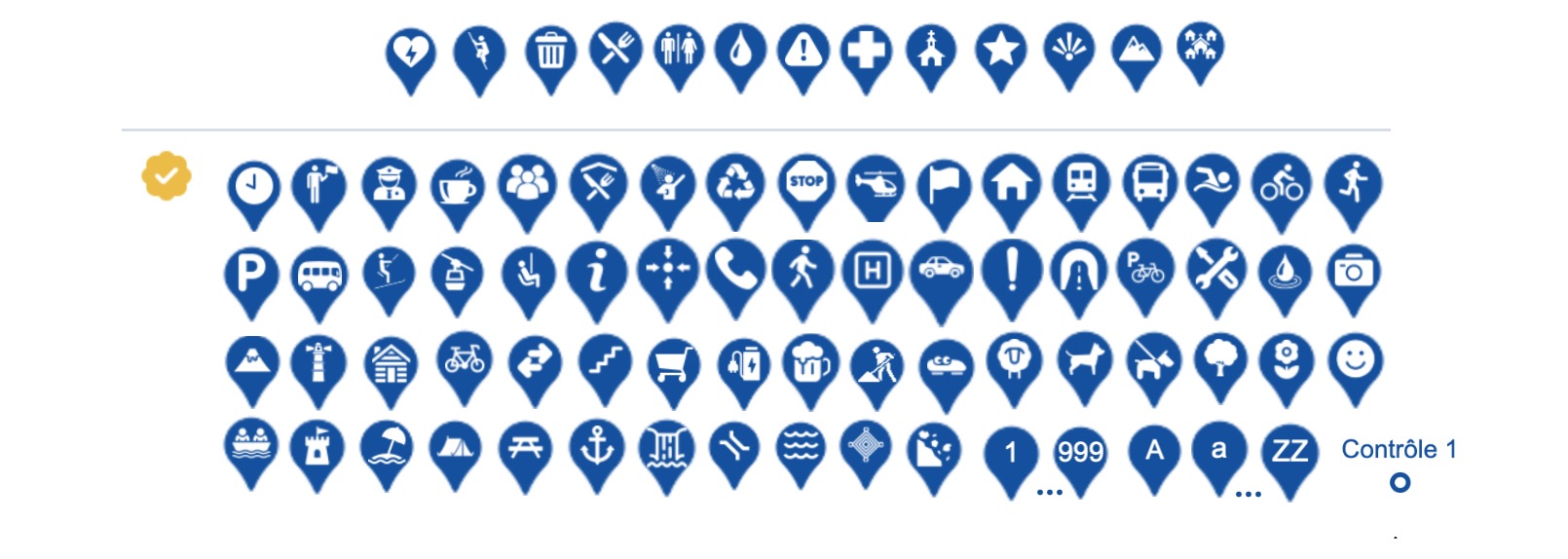
| Nombre de points d'intérêt différents disponibles | 14 | 84 | 84 |
| Points of interest spécial for volunteers management | |||
| Save the time table | |||
| Download times table (csv, pdf) | |||
| Customize points of interest: color, number... | |||
| Import points of interest from another track | |||
| Duplicate a point of interest | |||
| Add of points of interest as numbers or letters | |||
| Points of interest in the form of labels | |||
| WAYTYPES | |||
| Display waytipes (path, trail, road, etc.). Sources: IGN (France) or OSM database | |||
| Change waytipes - possibility of updating waytipes on parth of the road if it's not right | |||
| Management of bridges / tunnels / ski lifts ( remove height differences) | |||
| PERSONNALISED MAPS | |||
| Create a customised map : add tracks, polygons, points of interest | |||
| ELEVATION PROFILE | |||
| Altitude database available for calculating height differences | IGN, ASTERGDEM | IGN, ASTERGDEM | IGN, ASTERGDEM, Google |
| Customize the elevation profile | |||
| Use predefined profile templates | |||
| Use an other profile as template | |||
| Exportable profile size | Small (300px) | Medium (400px) | Large (400< <800px) |
| Advanced customisation tools: add labels, optional texts, intermediate distances and elevation changes, add POI customize colors | |||
| Premium customisation tools: add sections, choice of elevation profile size, add logo, fill with texture | |||
| Copy/paste POI style | |||
| VIEW A ROUTE | |||
| 3D view - available for all for official Premium Pro routes | |||
| View Streetview in a new window | |||
| View Streetview on the track | |||
| National maps (IGN, Swisstopo...) available for all users on official routes | |||
| View routes in full-screen mode | |||
| EXPORT - SHARE | |||
| Pdf printing | |||
| Export and customize a large-format pdf (A3-A0) for a track or multi-track map | |||
| Export gpx files | |||
| Export of a gpx compatible with the platform for declaring sporting events (France) | |||
| Quota of private tracks | 5 | 50 | Illimited |
| Sharing private tracks | |||
| Abo.comparatif.customizepdf | |||
| Number of gpx downloads per day (excepted tracks owned by the user) | 2 | 5 | 10 |
| Number of gpx downloads per month | 8 | 15 | 30 |
| Download GPX POI or download route + POI | |||
| Download in GeoJSON format (route + POI) | |||
| Download elevation profile points | |||
| ON YOUR WEBSITE | |||
| Display your track on your website | |||
| Display a multi-routes personalised map on your website | |||
| Display the time table on your website | |||
| Maps available in iframe | Plan IGN, OSM | Plan IGN, OSM | National maps |
| Premium iframe : full screen mode, remove advertising | |||
| TRAIL CONNECT APP | |||
| International maps | Google, OpentopoMap, OpenStreetMap | Google, OpentopoMap, OpenStreetMap | Google, OpentopoMap, OpenStreetMap, OpenCycleMap |
| French IGN maps | - | - | Cartes IGN, Scan25 IGN, Plan IGN, Images aériennes, Cartes topo IGN |
| National maps | - | - | Switzerland, Spain, Belgium |
| Search and view routes | |||
| Activity recording | |||
| Real-time geolocation | |||
| Monitoring alarm | |||
| Export gpx files | |||
| Download maps for offline access : OSM maps | |||
| Download maps for offline access : all national maps | |||
| OTHERS | |||
| Management with filess | |||
| Possibility to add routes to favorites | |||
| Personal dashboard | |||
| Abo.comparatif.officiel | |||
| PROMOTION - COMMUNICATION | |||
| Create and update an event in Trace de Trail calendar | |||
| Trace de Trail's Communication pack : promotion of your race via Trace de Trail's social networks (1 Facebook & Instagram post), invitation to participate in Trace de Trail marketing events |
Except for the monthly live tracking subscription, all other subscriptions are for one year. Renewal is automatic and will use the payment method you chose when you purchased the subscription.
You can switch from a Discover to a Premium subscription at any time. To do so, click on the Upgrade button on the subscriptions page.
- If you pay by credit card or PayPal, your subscription is activated immediately.
- If you pay by SEPA direct debit, the activation delay is typically 7 to 8 business days (up to 14 days). This corresponds to the time required for our payment provider, Stripe, to notify us whether the payment has been successful or has failed.
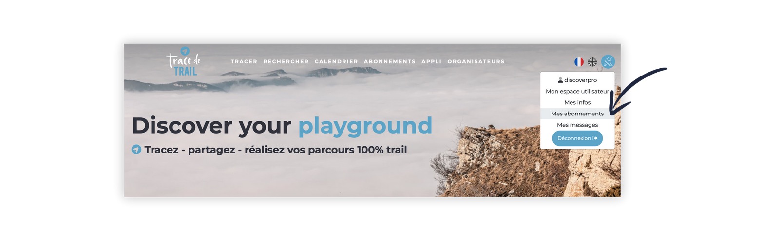
You will find all the information concerning your subscription in your user profile, section My subscriptions.
You may at any time :
- change your payment method,
- upgrade from Discover pro to Premium pro
- cancel your subscription.
Subscriptions to the Trace de Trail website and the Trail Connect mobile application are the same.
By subscribing to one or other of these platforms, you benefit from a common subscription that offers you functionalities on both interfaces.
Find out more about them in the subscription comparison table.
Here is the list of points of interest available with subscription
or without subscription for professionnal.
The color and size of all points of interest can be customized.
 Trace de Trail